East Grampian Coastal Partnership
www.stateofthecoast.scot
East Grampian Coastal Partnership
www.stateofthecoast.scot
Over the last decade, Scotland has almost doubled its Marine Renewable Energy generation. The energy transition, especially rapid offshore wind development and associated port/installation activity, is creating both direct spatial impacts and indirect effects for fishers based in North East Scotland. Large wind arrays and their exclusion safety zones reduce access to traditional fishing grounds and can fragment fishing areas, forcing vessels to travel further or concentrate effort into smaller remaining areas (Figure 1 and Figure 2).
Construction and operational activity also changes the marine environment (noise, habitat alteration, changes in hydrodynamics, and prey distribution) in ways that are still being studied; some fishers report altered catches near turbine sites and developers’ commonly identify disturbance and temporary loss of fishing grounds during construction (Figure 3). Although monitoring and compensation are inconsistent, fishers report economic and wellbeing struggles and heightened uncertainty about future viability. Recent UK studies and surveys of fishermen document social, economic and wellbeing stresses linked to wind development (Szostek et. al., 2025).
The transition affects shore-side dynamics too, major ports (e.g. Peterhead, Aberdeen) are evolving into service hubs for renewables and grid infrastructure. This can offer alternative employment that draws workers away from fishing, as well as causing competition for quayside space and storage. However, this may also increased ship capacity in the quayside and generally fishing boats are not competing with much larger wind vessels.
The main potential impacts of Offshore Windfarm developments on the commercial fishing industry identified within Environmental Impact Assessments, include:
1. Loss or restricted access to fishing grounds;
2. Changes in catch-rates;
3. Changes in target species
4. Displacement of fishing effort;
5. Increased steaming times;
6. Increased snagging risk;
7. Increased likelihood of vessel collision or allision; and
8. Increased interference with fishing gear.
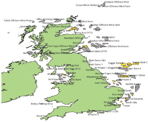
Figure 1: Map of wind farms in UK territorial waters that was presented in the online survey. Operational or under construction OWF (yellow), or future planned OWF (grey). Data from Crown Estate Open Data, as of November 2023.
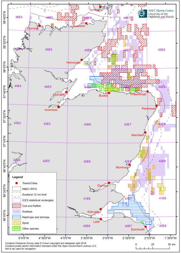
Figure 2: Summary of the main fishing areas by species based on available VMS information (sourced from ICES, 2017).
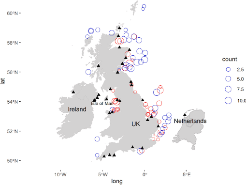
Figure 3: Frequency that respondents cited impacts to commercial fishing from wind farms currently operational or under construction (red circles), pre-construction or proposed (blue circles) as of November 2023, and home ports of survey respondents (black triangles).
Live - Next review due 15/01/2027
To report errors, highlight new data, or discuss alternative interpretations, please complete the form below and we will aim to respond to you within 28 days
Telephone: 07971149117
E-mail: ian.hay@stateofthecoast.scot
We need your consent to load the translations
We use a third-party service to translate the website content that may collect data about your activity. Please review the details in the privacy policy and accept the service to view the translations.