www.stateofthecoast.scot
www.stateofthecoast.scot
Pressures on marine spatial competition
Marine space in the East Grampian region is increasingly contested as multiple industries seek to expand in the North Sea waters offshore from Aberdeenshire and Aberdeen. Commercial fishing remains economically important in the area, with the value of landings for vessels under 12m around £19 million and £18 million for vessels over 12m in the wider East region (between Aberdeen and Arbroath). These fishing grounds support a range of fleet sectors and gear types that depend on access to productive sea areas for livelihoods and regional supply chains (Scottish Government, 2025).
Simultaneously, offshore wind development is expanding rapidly as part of Scotland’s contribution to national and UK climate policy goals, creating new and growing spatial competition between fishing and renewable energy sectors. The draft updated Sectoral Marine Plan for Offshore Wind Energy identifies multiple “plan option” areas for potential commercial wind development, contributing to a broader strategy that supported 27.6 GW of potential generation capacity in the ScotWind leasing round, a substantial footprint in Scottish waters (Scottish Government, 2025). Additionally, the proposed Green Volt offshore wind farm, centred about 80 km off northeast Scotland near Aberdeen with a planned capacity of 560 MW from 35 turbines, illustrates how floating wind technology is moving into marine spaces traditionally used by other maritime sectors.
This expansion of offshore wind and associated cabling and infrastructure corridors can reduce the extent of fishing grounds available to commercial fleets, a phenomenon industry representatives describe as “marine spatial squeeze.” Commentary on these developments has warned that rapid offshore renewable deployment could see large areas of productive Scottish waters become less accessible to fishing activity by 2050, posing risks to catch rates and coastal employment without careful planning and co-design (NFFO and SFO, 2022) (Figure 1, Figure 2). Stakeholders in the Scottish fishing sector have called for stronger assurance that marine planning frameworks will balance renewable energy development with the needs of fishing communities, emphasising early engagement and co-location strategies to reduce conflict and support coexistence.
Effective marine spatial planning (MSP) and integrated policy frameworks are central to managing these competing uses. MSP aims to allocate spatial and temporal distribution of human activities to achieve ecological, economic, and social objectives, recognising that unmanaged competition for marine space can lead to conflicts among sectors as well as potential harms to marine habitats (EGCP, 2025). In the East Grampian context, national sectoral plans for offshore wind sit alongside broader marine planning processes intended to manage trade-offs and support sustainable development, but stakeholders continue to emphasise the need for clearer policy integration, more robust stakeholder engagement, and mechanisms to mitigate spatial conflict as marine uses intensify (Scottish Government, 2025).
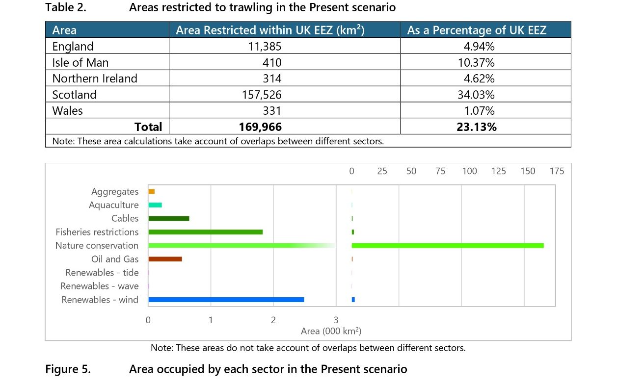
Figure 1: Areas restricted to trawling and area occupied by each sector in the in 2020/2021, NFFO
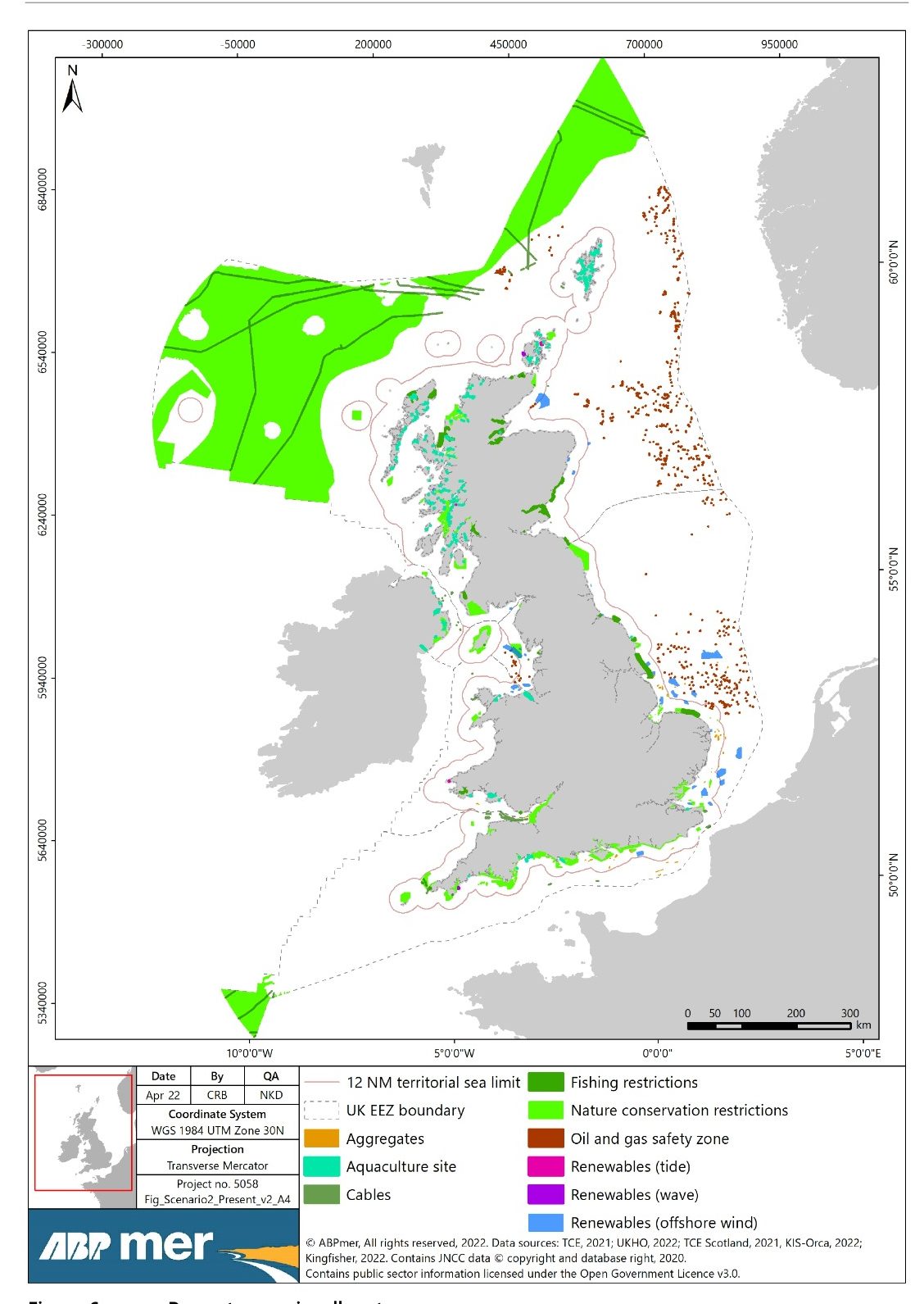
Figure 2: Map of area occupied by each sector in the in 2020/2021, NFFO
13/01/2026 by Corinne Meinert
24/01/2026 by Mariia Topol
Not Live - Next review due 24/01/2027
To report errors, highlight new data, or discuss alternative interpretations, please complete the form below and we will aim to respond to you within 28 days
Telephone: 07971149117
E-mail: ian.hay@stateofthecoast.scot
We need your consent to load the translations
We use a third-party service to translate the website content that may collect data about your activity. Please review the details in the privacy policy and accept the service to view the translations.